2 Map Guide
This guide serves to provide greater detail about functions within the Tribal Water Data Map.
2.1 Opening the Web Map
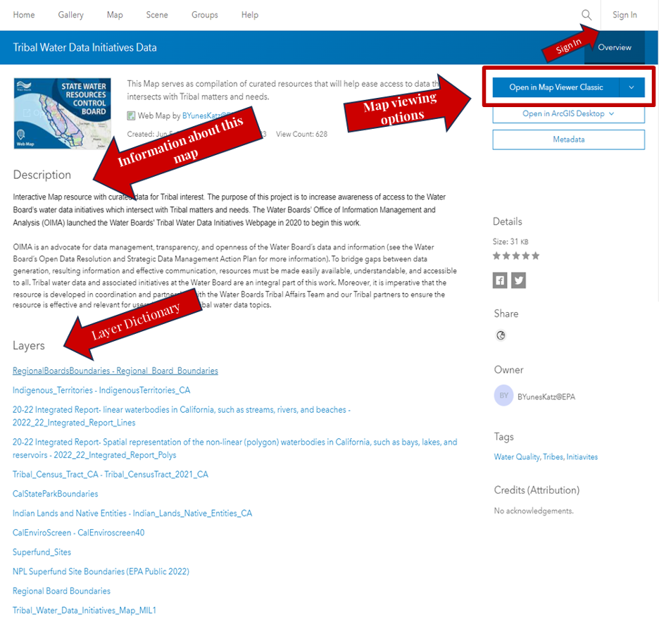
The link will take you to the main Portal of the map where you will find basic information like:
Map viewing options:
- If you have ArcGIS Desktop installed on the computer you are working on, you can opt to open the map directly on the App, otherwise just click on “Open Map Viewer” to open it.
Map description:
- A description of the map that highlights the purpose and goals.
Layer dictionary:
- You can click on each of the layers and find out more detailed information, including the source, a description of the source and the data, and the type of layer.
- If you only want to visualize one specific layer, you can click on the layer name in the Layer Dictionary and choose “Visualization” in the top right corner
2.2 Navigating the Map
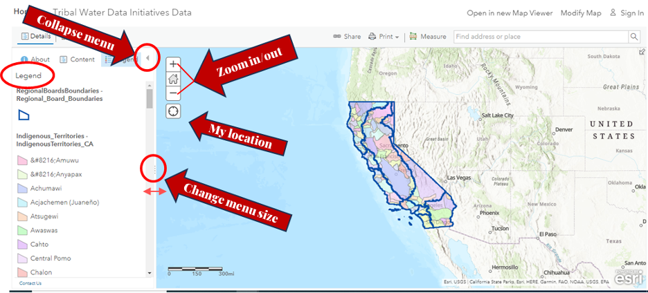
After you have clicked on ‘Open in Map Viewer’, the web map will open with two default layers being displayed: Regional Board Boundaries and Indigenous Territories.
To navigate the map:
To zoom you can use the Zoom in and Zoom out buttons on the bottom right of map, the mouse and wheel button, or press Shift + Plus Sign (zoom in) and Shift + Minus Sign (zoom out) on the keyboard. To zoom in, you can also press the Shift key while dragging a box on the map.
To go back to the main view, press the house icon.
Collapse the legend pane by clicking on the arrow on the upper-right corner of the menu.
Scroll through the map options in the sidebar on the left
- Map options include Layers, Tables and Charts, viewing the BaseMap, Viewing the Map Properties, and more.
- To expand the map options to see icons and words, click on the ‘>>’ arrows in the bottom lefthand corner (see Navigating Legend and Layers section below for picture).
To pan the map, use the mouse or the arrow keys on your keyboard.
If you’re using a Mac with OS X 10.6 or later, you can use multitouch gestures by dragging two fingers to pan and zoom the map. The default behavior is to pan. To zoom in or out, press Shift while dragging two fingers toward you to zoom in or dragging two fingers away from you to zoom out.
2.3 Navigating Legend and Layers
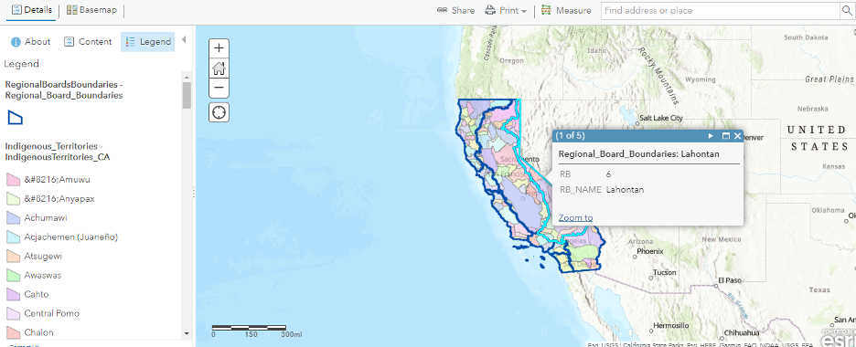
To see information on the map, click on any of the items in the menu bar on the left side of the screen. For example, to view other layers you can click on the Layers icon, which is displayed directly to the right of the menu bar.
Also in the menu bar, is the legend (shown in the inset below the pop-up menu). The legend gives more details about each layer that is currently selected. For example, the blue outlines and numbers are the Regional Board Boundaries and Designations, and the different Indigenous Territories are color coded and defined on that menu.
You can also click on a map area of California to find out what Regional Board, or Indigenous Territory is in a specific location. The information will be shown in a pop-up menu.
- In this example, the right border of California was clicked and a pop-up showed that the area belongs to Region 6 of the Regional Boards.
Additional map properties for exploration and analysis can be found on the panel on the right side of the screen for map properties and effects, to add a sketch, or to use measurement tools.
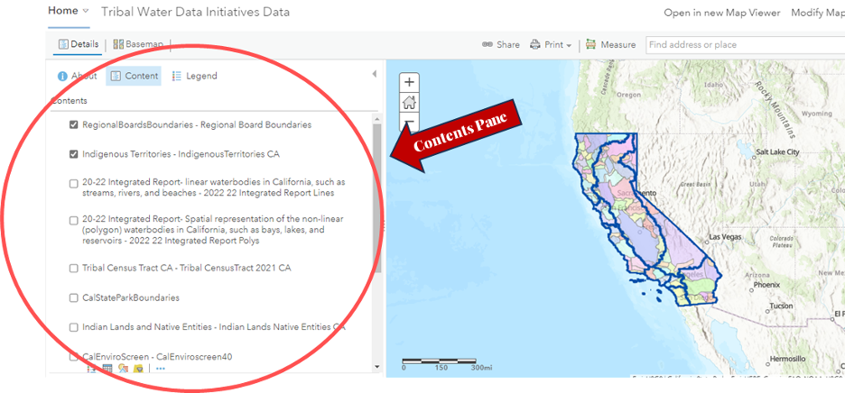
2.4 Displaying/Removing View of Layers
On the Menu Bar, click Layers . All the layers of the map will be listed (but not yet displayed). The layer categories (3.1, 3.2, 3.3, 3.4, 3.5, and 3.6) are coordinated with the section in the Layer Guide that outlines each layer and its important/relevant information.
Upon opening the map, only Regional Boards Boundaries and Indigenous Territories will be displayed. You can confirm this by looking at the layer name and seeing an eye icon (you may need to hover over the layer to see the eye icon). If the eye icon has a slash through it, that means the layer is not currently visible on the map. You need to click on the eye icon specifically to display/remove the layer.
- If you just click the layer name and not the eye icon, you will pull up the properties information about that layer on the right side of the map (shown on the right hand side for Tribal Census Tract 2021 layer).
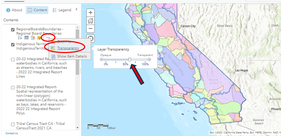
2.5 Adjusting Layer Transparency
To change the transparency of the layers:
Select the layer of which you’d like to change the transparency:
You can either click on the three dots next to the layer name and select “Show properties” or
You can click on the layer name and the properties panel will pop up on the right side of the screen.
Scroll down to Appearance
Select Transparency, and slide the button to the desired transparency
- The more transparency, the less visible the layer will be.